Python package to download data from gesdisc.eosdis.nasa.gov for Clear Sky Model, extract variables from the MERRA-2 reanalysis database and model of clear-sky irradiance.
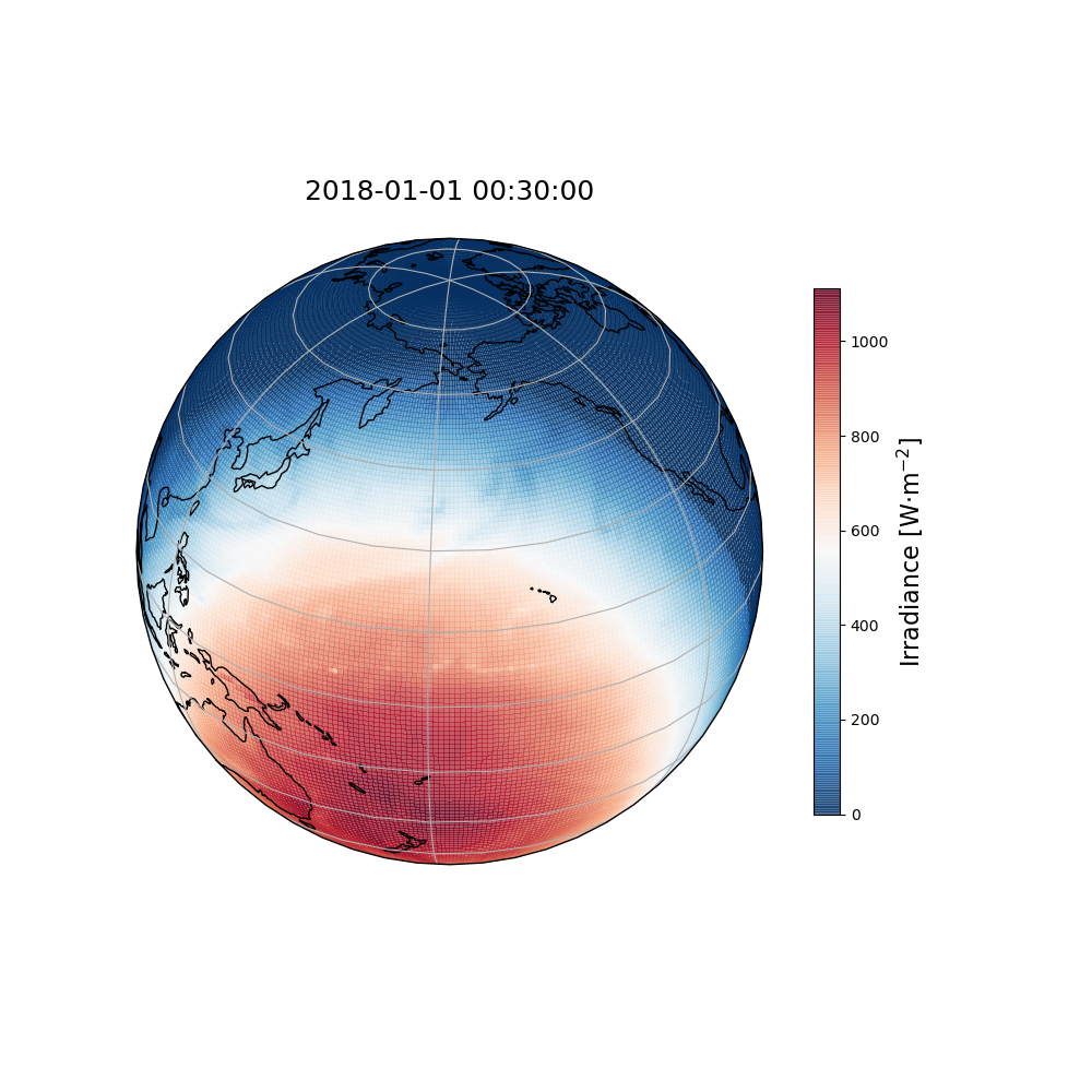
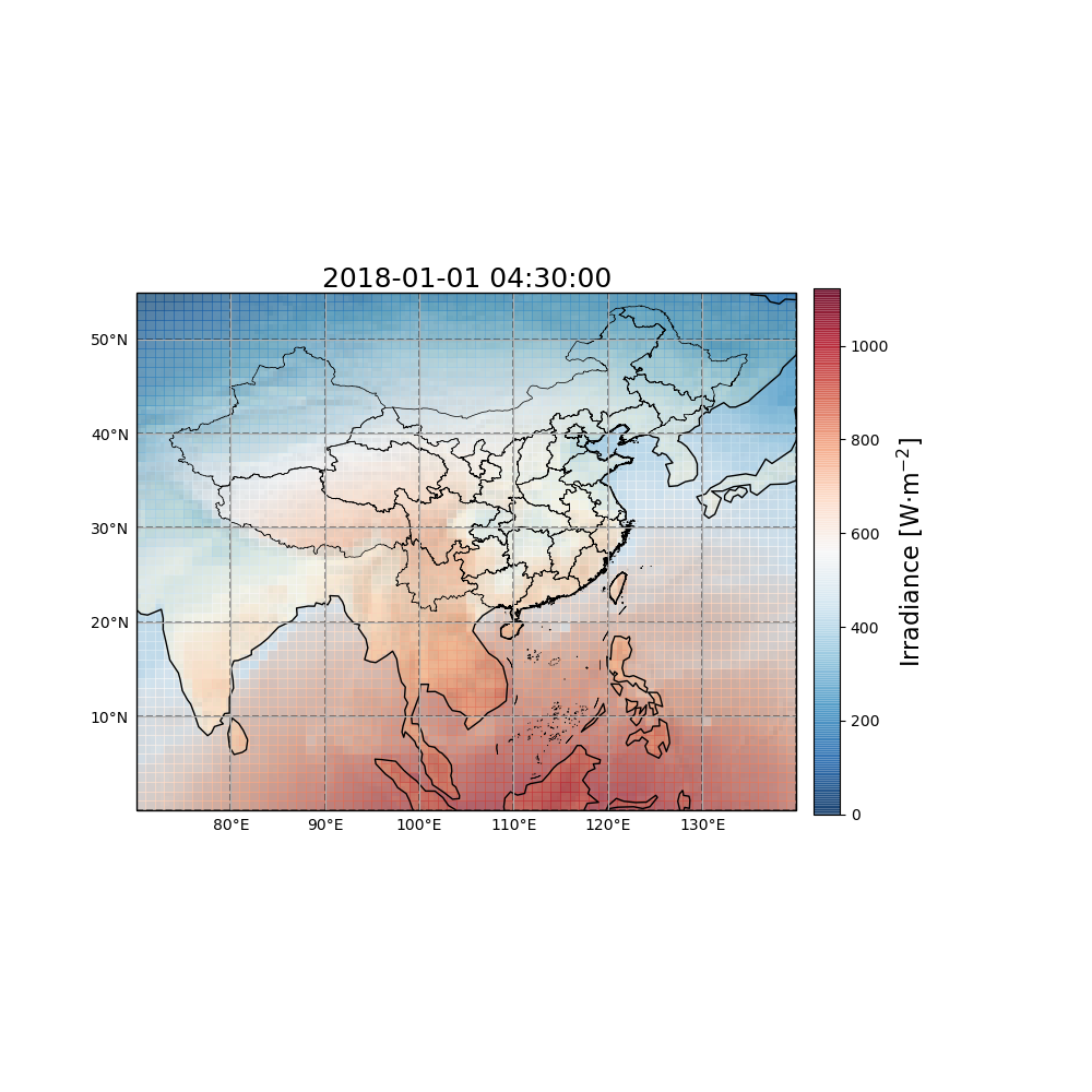
Using this tool, you can map out the global horizontal irradiance on a global basis or for a specific country.
Figures below are the output for 1st, January, 2018 to 2nd, January, 2018. Code is available at Python-IrradPy_Visualization.

- Skip already downloaded files.
- Automatically merge files by year.
- Allow multi-field selection for each table.
- Extract variables for a given time period from multiple MERRA-2 reanalysis databases.
- Automatic zenith angle calculation.
- Support two models: MAC2 and REST2 models.
- To Be Continue...
- Python >= 3.6
-
Register on GESDISC website and get your authentication.
-
Install the script to your computer.
- You can either download this package from the Github Release Page and Github Package Page, or clone this repository and run
python setup.py install.
- You can either download this package from the Github Release Page and Github Package Page, or clone this repository and run
-
Run the script.
-
Download data sets by downloader
-
Define latitude, longitude, elevation, time period for a model.
-
Run the model.
# Linux and Unix Users
import irradpy
# Run Downloader
irradpy.downloader.run(auth={"uid":"USERNAME", "password": "PASSWORD"})
# Run Model
irradpy.model.ClearSkyREST2v5(latitudes, longitudes, elevations, time, dataset_dir).REST2v5()
irradpy.model.ClearSkyMAC2(latitudes, longitudes, elevations, time, dataset_dir).MAC2()


# Windows Users Only:
import irradpy
import multiprocessing
# Important Note: If you're using windows, make sure to wrap the function.
if __name__ == "__main__":
    multiprocessing.freeze_support()
    irradpy.downloader.run(auth={"uid":"USERNAME", "password": "PASSWORD"})

# More Examples

# Download All Data From 2018-01-01 To 2018-01-02
irradpy.downloader.run(auth={"uid":"USERNAME", "password": "PASSWORD"},
    initial_year=2018, final_year=2018,
    initial_month=1, final_month=1,
    initial_day=1, final_day=2,
    lat_1=-90, lat_2=90,
    lon_1=-180, lon_2=180,
    verbose=True,
    thread_num=20, connection_num=2
    )

# Run clear sky model from 2018-01-01 To 2018-01-02
time_delta = 10  # minute
timedef = [('2018-01-01T00:00:00', '2018-01-02T0:00:00')]
time = irradpy.model.timeseries_builder(timedef, time_delta, np.size(latitudes))
irradpy.model.ClearSkyREST2v5(latitudes, longitudes, elevations, time, dataset_dir).REST2v5()
Parameters
#downloader:
collection_names : List[str]
Variable short names, must be defined in variables.py
if merra2_var_dict is not provided. If more than one variable,
they are assumed to have the same original files and those will only
be downloaded once.
initial_year : int
Initial year for the data to be downloaded.
Select from [1980, Now]
final_year : int
Final year for the data to be downloaded.
Select from [1980, Now]
initial_month : int
Initial month for the data to be downloaded.
Select from [1, 12]
final_month : int
Final month for the data to be downloaded.
Select from [1, 12]
initial_day : int
Initial day for the data to be downloaded.
Select from [1, 12]
final_day : Optional[int]
Final day for the data to be downloaded.
lat_1 : Optional[float]
Define the latitude of the left bottom corner of the rectangle region of interest.
Select a value from [-90, +90]
lon_1 : Optional[float]
Define the longitude of the left bottom corner of the rectangle region of interest.
Select a value from [-180, +180]
lat_2 : Optional[float]
Define the latitude of the right top corner of the rectangle region of interest.
Select a value from [-90, +90]
lon_2 : Optional[float]
Define the longitude of the right top corner of the rectangle region of interest.
Select a value from [-180, +180]
merra2_var_dicts : Optional[List[dict]]
Dictionary containing the following keys:
esdt_dir, collection, var_name, standard_name,
see the Bosilovich paper for details. Same order as collection_names.
output_dir : Union[str, Path]
auth : dict
Dictionary contains login information.
{"uid": "USERNAME", "password": "PASSWORD"}
verbose : bool
thread_num : Optional[int]
Number of Files to be downloaded simutanously.
connection_num : Optional[int]
Number of Connections for each file to be downloaded simutanously.
#irradpy.model.timeseries_builder:
timedef: list [(start time , end time)], optional — specify the start
time(s) and end time(s) of the location(s) of interest.
time_delta: integer, optional — specify the temporal resolution of the
time series in minutes
num_station: integer, compulsory - specify the station number of interest.
if timedef less than num_station, timeseries_builder will expand it
for every station.
#irradpy.model.clearSkyRadiation_MAC2.py && irradpy.model.clearSkyRadiation_REST2v5.py:
latitudes: numpy.ndarray, float, compulsory — Define the latitude(s) of the
location(s) of interest, size must match longitudes.
longitudes: numpy.ndarray, float, compulsory — Define the longitude(s) of
the location(s) of interest, size must match latitudes.
elevations: numpy.ndarray, float, compulsory — Define the elevation(s) of
the location(s) of interest, size must match lats.
time: numpy.ndarry of dtype ̄‘datetime64[m]’, compulsory — Define the time
series desired.
dataset_dir: Union[string, Path], optional — Define the location of the
dataset of downloaded and merged data.
python -m irradpy.downloader.socket --uid USERNAME --password PASSWORD

usage: socket.py [-h] [--collection_names VAR_NAMES]
                 [--download_dir DOWNLOAD_DIR] [--initial_year INITIAL_YEAR]
                 [--initial_month INITIAL_MONTH] [--initial_day INITIAL_DAY]
                 [--final_year FINAL_YEAR] [--final_month FINAL_MONTH]
                 [--final_day FINAL_DAY] --uid UID [--password PASSWORD]
                 [--bottom_left_lat BOTTOM_LEFT_LAT]
                 [--bottom_left_lon BOTTOM_LEFT_LON]
                 [--top_right_lat TOP_RIGHT_LAT]
                 [--top_right_lon TOP_RIGHT_LON] [--thread_num THREAD_NUM]
[--connection_num CONNECTION_NUM]merra2_downloader --uid USERNAME --password PASSWORD
usage: merra2_downloader [-h] --uid UID --password PASSWORD
[--collection_names COLLECTION_NAMES]
[--download_dir DOWNLOAD_DIR]
[--initial_year INITIAL_YEAR]
[--initial_month INITIAL_MONTH]
[--initial_day INITIAL_DAY] [--final_year FINAL_YEAR]
[--final_month FINAL_MONTH] [--final_day FINAL_DAY]
[--bottom_left_lat BOTTOM_LEFT_LAT]
[--bottom_left_lon BOTTOM_LEFT_LON]
[--top_right_lat TOP_RIGHT_LAT]
[--top_right_lon TOP_RIGHT_LON]
[--thread_num THREAD_NUM]
[--connection_num CONNECTION_NUM]
merra2_downloader: the following arguments are required: --uid, --passwordpython setup.py test| File Name | Purpose |
|---|---|
download.py |
main download logic |
variable.py |
define download urls and paths |
socket.py |
wrapper for downloader |
process.py |
wrapped download class |
| File Name | Purpose |
|---|---|
extract.py |
main extract logic |
| File Name | Purpose |
|---|---|
clearSkyRadiation_MAC2.py.py |
Clear Sky Model MAC2 Class |
clearSkyRadiation_REST2v5.py.py |
Clear Sky Model REST2 Class |
solarGeometry.py.py |
Basic function for clear sky model |
.
├── irradpy
│   ├── __init__.py
│   ├── downloader
│   │   ├── __init__.py
│   │   ├── download.py
│   │   ├── process.py
│   │   ├── socket.py
│   │   └── variables.py
│   ├── extractor
│   │    ├── __init__.py
│   │    └── extract.py
│   └── model
│        ├── __init__.py
│        ├── clearSkyRadiation_MAC2.py
│        ├── clearSkyRadiation_REST2v5.py
│        └── solarGeometry.py
├── README.md
├── setup.py
├── example
│   ├── example_downloader.py
│   └── example_clearsky.py
└── test
    └── test_downloader.py
.
└─ MERRA2_data
   ├── index.npy                            // logs for downloaded files
   ├── xxx_xxx_merra2_reanalysis_xxxx.nc    // merged file
   └── tmpxxxxxxxx                          // temp directory
       └── MERRA2_nnn.xxx.xxx.nc4.nc        // original files
With source code:
python setup.py installWith python package:
pip install -i https://test.pypi.org/simple/ irradpyThis project is licensed under MIT License, feel free to modify or contribute!

